GEN 3.2 Aeronautical charts
1. Responsible service
2. Applicable ICAO documents
- Annex 4 - Aeronautical Charts
- Doc 8697 - Aeronautical Chart Manual
- Doc 8168 - Aircraft Operations
3. Maintenance of Aeronautical charts
4. Purchase arrangements
ALBCONTROL Air Navigation Services of Albania Aeronautical Information Service P.O. Box 8172 Rinas, Tirana Albania
Tel:+355 4 2343487
Fax:+355 4 2343487
Email:ais@albcontrol.al
AFS:LAAAYNYX
5. Aeronautical chart series available
- Aerodrome Chart - ICAO;
- Aerodrome Ground Movement Chart - ICAO;
- Aerodrome Obstacle Chart - ICAO - Type A;
- Aircraft Parking/Docking Chart - ICAO;
- ATC Surveillance Minimum Altitude Chart - ICAO;
- Instrument Approach Chart - ICAO;
- Standard Arrival Chart - Instrument (STAR) - ICAO;
- Standard Departure Chart - Instrument (SID) - ICAO; and
- Visual Approach Chart - ICAO.
- Aerodrome Chart - ICAO
This chart contains detailed aerodrome data to provide flight crews with information that will facilitate the ground movement of aircraft from the aircraft stand to the runway, and from the runway to the aircraft stand.
It also provides essential operational information at the aerodrome. - Aerodrome Ground Movement Chart - ICAO
This chart provides flight crews with detailed information to facilitate the ground movement of aircraft to and from the aircraft stands and for the parking/docking of aircraft. - Aerodrome Obstacle Chart - ICAO - Type A (operating limitations)
This chart contains detailed information on obstacles in the take-off flight path areas of aerodromes. It is shown in plan and profile view. This obstacle information provides the data necessary to enable an operator to comply with the operating limitations of ICAO Annex 6, Part I, Chapter 5 and Part III, Section II, Chapter 3. - Aircraft Parking/Docking Chart - ICAO
This chart provides flight crews with detailed information to facilitate the ground movement of aircraft between the taxiway and the aircraft stands and the parking/docking of aircraft. - En-route Chart - ICAO
This chart is produced for the lower airspace within the Tirana FIR. The aeronautical data include all aerodromes, prohibited, restricted and danger areas and the air traffic services system in detail. The chart provides flight crews with information that will facilitate navigation along ATS routes in compliance with air traffic services procedures. - SECSI FRA - Index Chart
This chart shows SECSI FRA boundary, SECSI FRA entry and exit points with their relevance description and FRA intermediate points within the Tirana FIR. - Prohibited, Restricted and Danger Areas – Index Chart
This chart shows all airspace restrictions within the Tirana FIR including danger areas and other areas where a potential hazard to air navigation may exist. - Military Exercise and Training Areas – Index Chart
This chart portrays areas of established military training activity and military exercises within the Tirana FIR taking place at regular intervals. - Aerial Sporting and Recreational Activities – Index Chart
This chart portrays areas of intensive aerial sporting and recreational activities within the Tirana FIR. - Standard Departure Chart - Instrument (SID) - ICAO
This chart provides the flight crew with information to enable it to comply with the designated standard departure route-instrument from take-off phase to en-route phase. The aeronautical data shown include the aerodrome of departure, aerodrome(s) which affect the designated standard departure route-instrument, prohibited, restricted and danger areas, minimum sector altitude and the air traffic services system. - Omni-Directional Departure Area
An omnidirectional departure procedure permits a turn in any direction after reaching a specified altitude/height. It is a convenient and flexible method of ensuring obstacle clearance.
An omnidirectional departure area specifies sectors with altitude or PDG limitations or sectors to be avoided. - Standard Arrival Chart - Instrument (STAR) - ICAO
This chart provides the flight crew with information to enable it to comply with the designated standard arrival route-instrument from the en-route phase to the approach phase. The aeronautical data shown include the aerodrome of landing, aerodrome(s) which affect the designated standard arrival route-instrument, prohibited, restricted and danger areas, minimum sector altitude and the air traffic services system. - ATC Surveillance Minimum Altitude Chart - ICAO
This chart provides information that enable flight crews to monitor and cross-check altitudes assigned by a controller using an ATS surveillance system. - Instrument Approach Chart - ICAO
This chart provides flight crews with information to enable them to perform an approved instrument approach procedure to the runway of intended landing including the missed approach procedure and, where applicable, associated holding patterns. A separate Instrument Approach Chart - ICAO has been provided for each non-precision approach procedure. The aeronautical data shown include information on aerodromes, obstacles, prohibited, restricted and danger areas, radio communication facilities and navigation aids, minimum sector altitude or terminal arrival altitude, portrayal of procedure track, aerodrome operating minima, etc. - Visual Approach Chart - ICAO This chart provides flight crews with information which enable them to transit from the en-route/descent to approach phases of flight to the runway of intended landing by means of visual reference. The aeronautical data shown include information on aerodromes, obstacles, prohibited, restricted and danger areas, designated airspace, visual approach information, radio navigation aids and communication facilities, as appropriate.
- Aeronautical Chart - ICAO 1:500 000
This chart provides information to satisfy the requirements of visual air navigation for low speed, short or medium range operations at low and intermediate altitudes. It is also used in pre-flight planning and for basic pilot and navigation training. Airspace information up to FL115 and obstacles higher than 100 m AGL are depicted.
In addition to aeronautical information, the charts provide hydrographic, topographic, cultural and other visual features compatible with legibility at the scale of the chart.
6. List of aeronautical charts available
Title of Series | Scale | Name and/or Number | Price | Date |
En-route Chart - ICAO* | 1:1 700 000 | Tirana FIR | - | 29 DEC 2022 |
SECSI FRA - Index Chart* | 1:4 500 000 | SECSI FRA | - | 13 JUL 2023 |
Prohibited, Restricted and Danger Areas – Index Chart* | 1:1 500 000 | Tirana FIR | - | 29 DEC 2022 |
Aerial Sporting and Recreational Activities – Index Chart * | 1:1 500 000 | Tirana FIR | - | 29 DEC 2022 |
Military Exercise and Training Areas – Index Chart* | 1:1 500 000 | Tirana FIR | - | 18 MAY 2023 |
Aerodrome Chart (ADC) - ICAO* | 1:18 000 1:12 500 | LATI LAKU | - - | 29 DEC 2022 12 AUG 2021 |
| Aircraft Parking/Docking Chart (APDC) - ICAO* | 1:5 000 | LATI | - | 23 MAR 2023 |
Aerodrome Ground Movement Chart (AGMC) - ICAO* | 1:12 000 | LATI | - | 18 MAY 2023 |
Aerodrome Obstacle Chart (AOC) - ICAO* - Type A | 1:20 000 1:20 000 1:20 000 | LATI RWY 17 LATI RWY 35 LAKU RWY 01 | - - - | 23 MAR 2023 29 DEC 2022 17 JUN 2021 |
Standard Departure Chart - Instrument (SID) - ICAO* | 1:250 000 1:1 000 000 1:1 000 000 | LAKU RWY 01 LATI RNAV RWY 17 LATI RNAV RWY 35 | - - - | 12 AUG 2021 13 JUL 2023 13 JUL 2023 |
Omni-Directional Departure Area* | 1:500 000 | LATI RWY 17 | - | 29 DEC 2022 |
Standard Arrival Chart - Instrument (STAR) - ICAO* | 1:350 000 1:500 000 1:500 000 | LAKU RWY 19 LATI RNAV RWY 17 LATI RNAV RWY 35 | - - - | 12 AUG 2021 13 JUL 2023 13 JUL 2023 |
ATC Surveillance Minimum Chart - ICAO* | 1:900 000 | LATI | - | 13 JUL 2023 |
Instrument Approach Chart (IAC) - ICAO* | 1:500 000 1:500 000 1:500 000 1:500 000 1:500 000 1:350 000 | LATI ILS or LOC RWY 17 LATI VOR RWY 17 LATI VOR RWY 35 LATI RNP RWY 17 LATI RNP RWY 35 LAKU RNP RWY 19 | - - - - | 13 JUL 2023 13 JUL 2023 13 JUL 2023 13 JUL 2023 13 JUL 2023 12 AUG 2021 |
Visual Approach Chart (VAC) - ICAO* | 1:300 000 1:250 000 | LATI LAKU | - - | 13 JUL 2023 16 JUN 2022 |
Visual Approach Procedure Chart* | 1:100 000 | LAKU | - | 12 AUG 2021 |
| Aeronautical Chart - ICAO | 1:500 000 | Albania | - | 29 DEC 2022 |
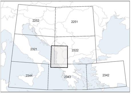
7. Index to the World Aeronautical Chart (WAC) - ICAO 1:1 000 000

8. Topographical charts
Ministry of Defence
Military Institute of Geography and Infrastructure
Department of Surveys
Tirana, Albania
Tel:+355 4 2363427
Fax:+355 4 2363427
Email:igju@albmail.com
9. Corrections to charts not contained in the AIP
| Chart | Location | Correction |
| Aeronautical Chart - ICAO 1:500 000 | Albania | Change to the magnetic variation. Removal of restricted areas LAR3B and LAR3C. Changes to the lateral limits of Tirana CTR. Introduction of new VFR entry/exit points in Tirana CTR. Introduction of new obstacles in Area 1. |
| Consult NOTAMs for latest information concerning air navigation obstacles. | ||